
Why OVER’s VPS Outperforms GPS: A Deep Dive into Spatial Computing
2024-08-22
OVER: Pioneering Decentralized Spatial Computing
OVER was born in 2020 as a Decentralized Spatial Computing Platform, since its inception, the vision has been to create an uncensorable infrastructure to augment the physical world through what has been called AR, MR, XR, and lately, Spatial Computing.
But what is Spatial Computing anyway? The difference between spatial and traditional computing is spatial awareness. Under the spatial computing paradigm information and contents are contextualized in space and into specific locations. The devices that deliver such content are aware and capable of computing both their global location (coordinates) and the physical 3D structure of the space they are in, coherently blending content with it.
The Core of Spatial Computing: Why VPS is Essential
There are several components that enable Spatial Computing, but at its core, the system needs to connect 3D experiences to physical locations, be able to precisely understand where the streaming device is in space, and compute in real-time position and occlusions.
OVER leverages OVRLand NFTs as spatial domains, publishing rights to connect experiences to geographic coordinates and OVRMaps both as a reference of the 3D space where content is published for creators, and as data layer leveraged by the OVER Visual Positioning System (VPS) to precisely re-locate in space.
But why use VPS and not other systems like GPS, Beacons, or QR Codes you may ask? There are four main principles that guided us in such a choice:
- Censorship resistance
- Indoors re-localization accuracy
- Availability of the re-localization system for AR devices
- Precision
Let’s go through the different re-localization technologies to see how they compare to VPS:
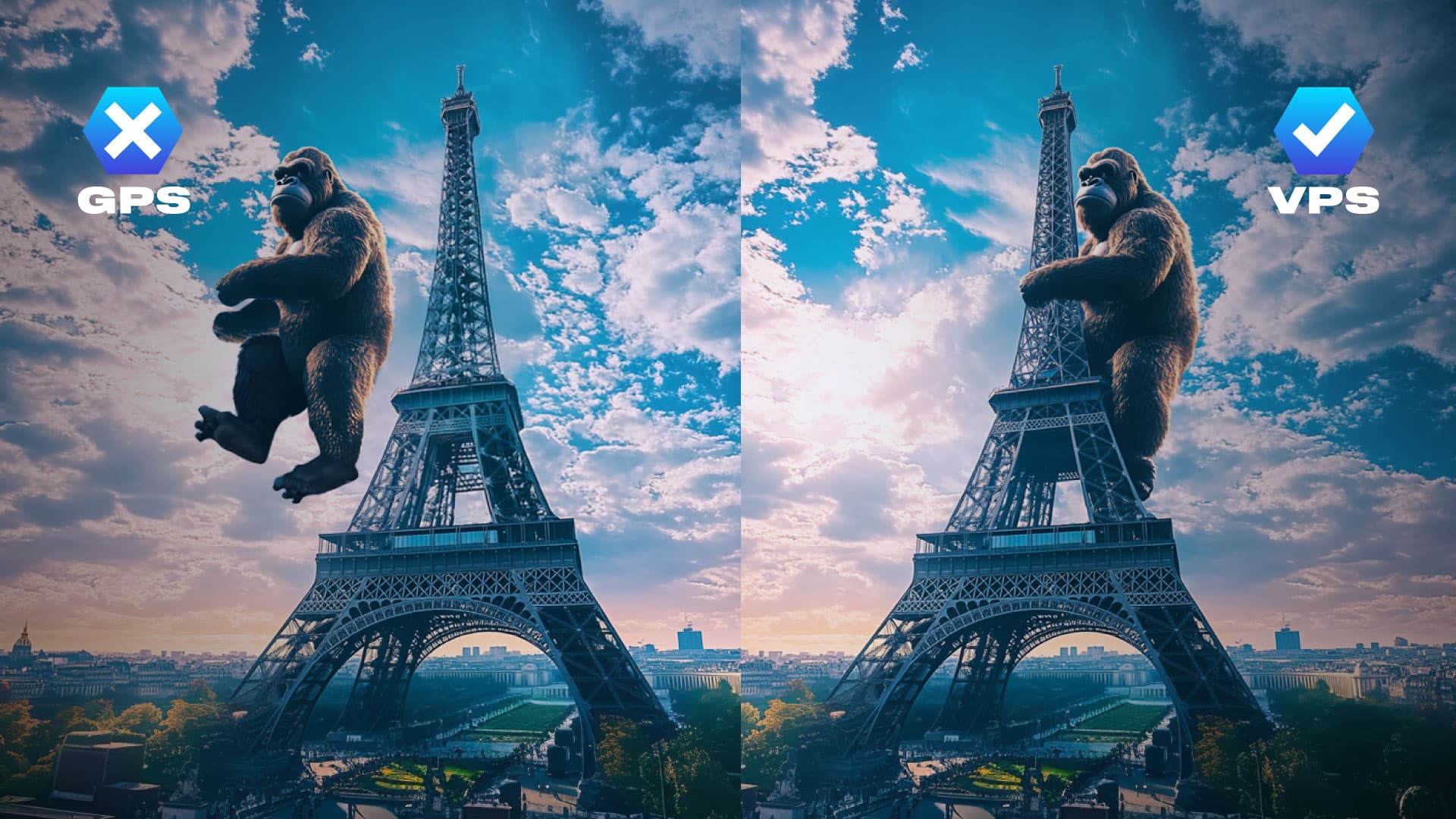
- GPS: is a solution to localize in space with low precision, is based on a publicly accessible infrastructure of satellites, is censorship resistant (excluding extreme scenarios), and can be easily accessed with almost any smartphone with on-edge computation. On the downside, it is very imprecise indoors and in locations with tall buildings. Is a good system to get a rough idea of where you are in space, yet it is not precise enough for most of the spatial computing use cases.
- VPS: is a solution to localize in space with high precision, it is censorship resistant – as long as you can use an electronic device with a camera – since it leverages the visual appearance of locations, it can be performed both on edge and on the cloud. The downside compared to GPS is that it requires preliminary 3D mapping of the target location, an activity that, through the OVER mapping tool, requires 3-5 minutes for an area of 300 sqm. An important feature that is not shared by any of the other systems is that the data structures that empower VPS also entail the understanding of the 3D structure of physical locations and thus enable the creation of remotely explorable digital wins of the mapped location. It is the only solution that supports all of the spatial computing use cases.
- Magnetic fields: is a solution to localize in space with medium precision, it is censorship resistant since it leverages the magnetic field of the target locations (similarly to what VPS does with the visual field). It leverages on-edge computation yet it requires the device to be equipped with a magnetic compass (not all devices are equipped with it). It requires contextualization/calibration. It is not precise enough for all of the spatial computing use cases.
- Wifi: is a solution to localize in space with medium precision, it is censorship resistant since is based on a “public good”, the existing wifi networks of the target location. Is based on on-edge computation leveraging device Wifi capabilities. On the downside, contrary to GPS, Wifi is not globally distributed, so the system will work only if there are existing Wifi hotspots, it requires calibration/contextualization. It is not precise enough for all of the spatial computing use cases and it is very sensitive to updates to the wifi network infrastructures.
- Beacons: is a solution to localize in space with medium precision, it is not censorship resistant since it requires permission for the installation of physical devices. Is based on on-edge computation, and it leverages Bluetooth/Wifi hardware of devices. On the downside, compared to both GPS and VPS, it is costly (cost of the devices + installation) and requires maintenance (power supply) and contextualization/calibration. It is not precise enough for all of the spatial computing use cases.
- QR Codes/Visual markers: this is one of the oldest techniques in AR and is a solution to localize in space with high precision. It is not censorship-resistant since it requires permission to install visual markers in the target physical space. Is based on on-edge computation leveraging the camera and SLAM of the device. As for Wifi, Beacons and Magnetic Fields, it requires additional contextualization in space and calibration. It is precise enough for some spatial computing use cases, yet it lacks spatial awareness.
The Need for a Decentralized Localization System
Considering the goal of creating a decentralized infrastructure for Spatial Computing, OVER had to exclude by default permissioned Localization Systems such as QR Codes/Visual Markers and Beacons. Decentralization is a means to an end that is censorship resistance, it would be illogical to build a decentralized localization system where you need to ask permission to install QR Codes or Beacons. Leveraging Wifi and/or Magnetic Fields could have been a solution but the lack of ubiquity of the first one and the requirement for a magnetic compass of the second one undermines the application scope of such tech. The only logical solution to the problem of building a censorship-resistant global localization system is combining GPS for rough localization and VPS for precise localization and context/3D space awareness.
The OVER VPS system is already fully functional, with more than 50k OVER VPS-enabled locations around the world. The number of mapped locations is growing at a staggering pace, we expect to hit the 100k 3DMaps mark before the end of this year, making OVER the largest Spatial Computing platform in terms of VPS-enabled locations, going even beyond Niantic, our largest Web2 competitor, that currently declares a total 100k VPS enabled locations. Finally, this goes beyond the utility for the OVER platform users, the OVER VPS system is valuable for any third party interested in spatial computing and re-localization and they will soon be able to tap into this system.
VPS is the portal to the Spatial Web, it is paramount that this infrastructure is build on Web3, join us to create the largest 3D Map of the world that you can own!